
 |
|
| THE MOUNT GRAPPA | |
| Access to the Mount Grappa | |
| Flora & Fauna | |
| Topographics | |
| The Big War |
|
| Montegrappa History | |
| Montain Community |
|
| Eastern Grappa | |
| FREE FLIGHT | |
| Free Flight home |
|
| Flights free para gliding |
|
| Flights free hang gliding |
|
| Aec Montegrappa | |
| Photographic Gallery | |
| CLIMBING | |
| Free Climbing |
|
| Arenas Indoor |
|
| Grappa Falaise |
|
| Cai Bassano of the Grappa | |
| OTHER ASSET | |
| Corlo Lake | |
| Water Earth Sky |
|
| Horse - riding |
|
| Excursions | |
| Snow Board |
|
| Activities on Brenta river |
|
| Motobike Quad |
|
| Mountain Guide |
|
| Swimmingpool |
|
| ASS. MONTEGRAPPA.ORG | |
| Who we are |
|
| How to join us |
|
| Conventional Partner |
|
| Photographic Gallery | |
| USEFUL INFORMATION | |
| Farm Holidays |
|
| Hotel & Guests house |
|
| Bed & Breakfast |
|
| Pub |
|
| Pizzerie |
|
| Camping |
|
| Restaurants |
|
| Others |
|
| Information
request |
|
| Weather Forecast | |
| Web Sponsor |
|
| Useful Links |
|
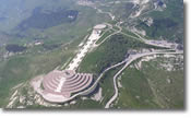 |
GEOMORPHOGRAPHICS.... Monte Grappa presents itself in two sections completely different, identified by a system of valleys, and even these valley's have different caracteristics, depending on which section of the mountain they are present. These sections are divided in: Situated on the borders of the provinces of Vicenza, Treviso and Belluno, is the highest mountain located in the Veneto Prealpi region. Bordered by the flat plains on the south, the Valsugana to west, the river Piave to the east, the valley Feltrina and the Corlo lake to the north, it is well separated from the nearby mountain systems, with it's peak height at 1775m above sea level. It is famous for its sacred ossuary built to remember the bloody battles fought on the mountain during the first world war. |